


Lambert Twp. Voting District, Red Lake County, Minnesota
About
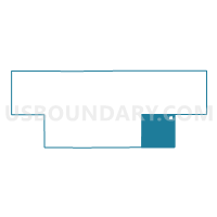
Outline

Summary
| Unique Area Identifier | 603963 |
| Name | Lambert Twp. Voting District |
| County | Red Lake County |
| State | Minnesota |
| Area (square miles) | 35.77 |
| Land Area (square miles) | 35.77 |
| Water Area (square miles) | 0.00 |
| % of Land Area | 100.00 |
| % of Water Area | 0.00 |
| Latitude of the Internal Point | 47.80384440 |
| Longtitude of the Internal Point | -95.90256350 |
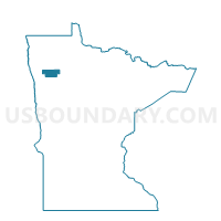
Maps

Graphs
Select a template below for downloading or customizing gragh for Lambert Twp. Voting District, Red Lake County, Minnesota


Neighbors
Neighoring Voting District (by Name) Neighboring Voting District on the Map
- Badger Twp. Voting District, Polk County, MN
- Chester Twp. Voting District, Polk County, MN
- Emardville Twp. Voting District, Red Lake County, MN
- Equality Twp. Voting District, Red Lake County, MN
- Garnes Twp. Voting District, Red Lake County, MN
- Hill River Twp. Voting District, Polk County, MN
- Lessor Twp. Voting District, Polk County, MN
- Oklee Voting District, Red Lake County, MN
- Poplar River Twp. Voting District, Red Lake County, MN
Top 10 Neighboring County Subdivision (by Population) Neighboring County Subdivision on the Map
- Oklee city, Red Lake County, MN (435)
- Emardville township, Red Lake County, MN (195)
- Garnes township, Red Lake County, MN (190)
- Lessor township, Polk County, MN (175)
- Hill River township, Polk County, MN (157)
- Equality township, Red Lake County, MN (131)
- Lambert township, Red Lake County, MN (129)
- Badger township, Polk County, MN (117)
- Poplar River township, Red Lake County, MN (107)
- Chester township, Polk County, MN (75)
Top 10 Neighboring Place (by Population) Neighboring Place on the Map
Top 10 Neighboring Unified School District (by Population) Neighboring Unified School District on the Map
- Win-E-Mac School District, MN (3,465)
- Oklee Public School District, MN (1,186)
- Plummer Public School District, MN (819)
Top 10 Neighboring State Legislative District Lower Chamber (by Population) Neighboring State Legislative District Lower Chamber on the Map
Top 10 Neighboring State Legislative District Upper Chamber (by Population) Neighboring State Legislative District Upper Chamber on the Map
Top 10 Neighboring 111th Congressional District (by Population) Neighboring 111th Congressional District on the Map
Top 10 Neighboring Census Tract (by Population) Neighboring Census Tract on the Map
- Census Tract 209, Polk County, MN (3,876)
- Census Tract 210, Polk County, MN (3,592)
- Census Tract 101, Red Lake County, MN (1,868)